Old Satellite Images of Your Land: What 10 Years Reveal
Free ways to see old satellite images of your land in India, their limits, and what a year-by-year history reveals about crops, structures and the 12-year rule.
By the PlotPehra Land DeskUpdated 6 min read



Your land’s 10-year diary
On this page
Every field in India has been photographed from space many times over the last decade. Those old images are a quiet diary of your land — who farmed it, when the ground was dug, when a roof went up. Here is how to look at them yourself, what they can and cannot show, and why the dates matter.
Can you see old satellite images of your land for free?
Yes. Two free options cover most people's needs: Google Earth's historical imagery and the Copernicus Sentinel image browsers. Both let you move back through time over your village, and neither needs any special software skills.
Google Earth historical imagery
The desktop version of Google Earth has a historical imagery feature — a small clock icon with a time slider. Move the slider and you see older images of the same spot, often from several different years.
The pictures are usually sharp, so you can recognise buildings, trees and field boundaries. But the dates are irregular. Your village might have three images from one year and none for the next four.
On a phone, our free historical satellite imagery viewer does something similar with Esri's archive: it lists every different image of your spot since 2014 and lets you swipe between two years, with the date each photo was taken.
Copernicus and Sentinel browsers
The European Space Agency's Copernicus programme publishes free imagery from Sentinel-2 satellites. Public web browsers built on this data let you pick a date and view your area in true colour or in vegetation views.
Sentinel-2 passes over roughly every five days, so you get many dates each year. The catch is detail: each pixel covers 10 metres by 10 metres, so a small plot is only a few pixels wide.
What are the limits of free satellite imagery?
Free imagery is a great start, but it is easy to misread. The main limits are:
| Limit | Google Earth history | Sentinel-2 browsers |
|---|---|---|
| How often | Irregular — gaps of months or years | Frequent — about every 5 days |
| Detail | Often sharp enough to see buildings | 10 m pixels — fields, not sheds |
| Clouds | Mostly cloud-free picks | Many monsoon dates are cloudy |
| Finding your plot | You must know where the boundary is | Same, and harder at this scale |
| Interpretation | Entirely up to you | Entirely up to you |
Clouds and the monsoon
Optical satellites cannot see through clouds. During the monsoon months, many Sentinel-2 dates show only white. Radar satellites such as Sentinel-1 do see through cloud, but SAR radar images are grainy and hard to read for a single small plot. The practical answer for history is to compare clear dates from before and after each monsoon. Our post on whether satellites can see your land in the monsoon explains how long the gaps usually last.
Finding the right boundary
Old images do not come with your khasra lines drawn on. If you misjudge the boundary by one field, you may end up studying your neighbour's crops for an hour.
Knowing what you're looking at
A brown patch could be a harvested field, fresh digging, or a new brick kiln. A green patch could be your tenant's wheat or someone else's. Telling these apart takes practice.
What does a 10-year history of your land actually reveal?
A year-by-year history shows patterns, not just snapshots. Seen together, the images often tell a clear story about how the land has been used and when that changed.
Things a history can reveal:
- When cultivation started or stopped. Seasonal green-up in a field that used to stay bare is a strong sign someone began farming it. Vegetation indices like NDVI make this easier to see.
- When structures appeared. A roof, a tube-well room, a cattle shed or a boundary wall usually shows up clearly in sharper images.
- When boundaries moved. A fence line or bund that creeps into your plot over a few seasons is easier to spot across years than in one picture.
- Digging, dumping and clearing. Bare soil, pits or cleared trees often mark the start of construction or sand mining.
- Long quiet periods. Just as useful — years of no change are reassuring evidence that nothing happened.
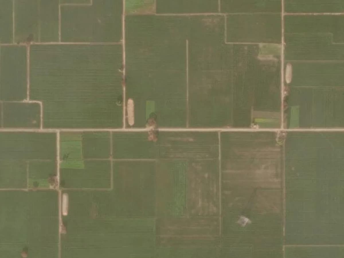
Drag the slider below to see how the same plot can look in two different years.
 AugustSeptember
If you are unsure what the early signs look like on the ground, our checklist of signs someone is using your land is a good companion.
Why do the dates matter for the 12-year rule?
Because the clock under the 12-year rule starts on a date. Under Article 65 of the Limitation Act 1963, you generally have 12 years to sue for possession of private land, counted from when the other person's possession became adverse to you.
That means "when did this start?" is often the key question in a dispute. If someone claims they have farmed your land openly for 14 years, images showing it was bare until four years ago can matter a great deal. The reverse is also true — images may show that the use started earlier than you thought, which tells you to act quickly.
Our full guide to adverse possession and the 12-year rule goes deeper, including the myth of a "3-year" rule. For how images might be used as evidence in your case, talk to a local property lawyer.
Should you do it yourself or get a report?
Doing it yourself is worthwhile if you have time, know exactly where your boundary is, and only want a rough sense of what happened. Start with Google Earth, then use a Sentinel browser to fill in the gaps.
A simple way to start on your own
- Find your village in Google Earth and mark the plot as best you can, using a road, canal or well as a landmark.
- Open the historical imagery slider and note the date of every image where the plot is visible.
- For each date, write one line: bare, crop, structure, or unclear.
- Use a Sentinel browser to check the years Google Earth skips, focusing on the post-monsoon and winter months when skies are clearer.
- Save screenshots with the date visible, and keep them in one folder.
Even a rough table like this is useful. It turns "I think someone started farming it a few years ago" into something you can show a lawyer or a sibling.
A report makes more sense when:
- You need a clear, dated record to share with family or a lawyer.
- The plot is small, and you are not sure where the boundary lies.
- You want monsoon gaps filled and someone to explain what each change means.
How does the PlotPehra Land History Report work?
The Land History Report is a one-time PDF covering up to 10 years of satellite history for your plot. You give us a survey or khasra number with village and district, or drop a pin on a map. No power of attorney, ever.
We locate the plot, pull the imagery year by year, and a real person marks when crops, bare soil or structures appear, with the date of each image. You can see the format in our sample report. If we cannot locate the plot or deliver the report, you get a full refund.
Once you know the story so far, you can decide whether to keep watching the land, and its land record, going forward. Either way, the old images are already there — it is worth knowing what they say.
Questions people ask
Yes. Google Earth's historical imagery feature and Copernicus Sentinel browsers both let you look back in time at no cost. The trade-off is patchy dates and doing all the interpretation yourself.
It depends on the source. Sentinel-2 imagery is available from its launch in the mid-2010s, while Google Earth's history for a village may include older images at irregular intervals.
They can often narrow it down to a season or a year, for example when bare land first shows a crop or when a roof first appears. They are strong supporting evidence, but talk to a local property lawyer about how to use them in a dispute.
Sentinel-2 pixels are 10 metres across, so a small plot may be only a handful of pixels. It is excellent for spotting crop and soil changes, less so for small details like a single shed.
About the PlotPehra Land Desk
Our team reviews satellite and land-record changes on NRI-owned land across India, and writes these guides from the questions families ask us. We’re not lawyers — for legal decisions, always speak to a local property lawyer. More about us · How we research our guides.